
Walk down any street in South Kensington, Notting Hill, or Islington and you see them everywhere: row after row of red-brick terraced houses, their white stucco trim picked out against Victorian brick, their iron railings casting long shadows on the pavement. Victorian builders constructed these streets by the hundred thousand between 1837 and 1901. Today, they define what most visitors picture when they imagine London.
But who built these houses? Who lived in them? And what stories do their walls contain?
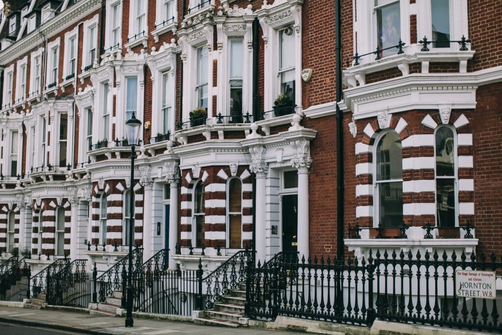
How the Victorians Built an Entire City in 64 Years
When Queen Victoria took the throne in 1837, London held about two million people. When she died in 1901, it held six million. The city had to expand — and it expanded fast.
Developers and speculators bought farmland on the edges of the existing city and laid out street after street of terraced houses. They worked to a formula. Wide streets carried houses of four or five storeys for wealthy families. Narrower streets behind them held three-storey houses for clerks and shopkeepers. Narrower streets still had two-storey cottages for working-class families.
The houses look similar because they came from the same pattern books. Architects published standard designs that builders copied street by street and neighbourhood by neighbourhood. The result is a city of remarkable visual consistency — and, once you learn to read it, a surprisingly clear map of who lived where and what they earned.
The Great Exhibition of 1851 drove the first wave of house building in South Kensington. Prince Albert and the exhibition’s organisers wanted a new cultural quarter near Hyde Park. Developers raced to meet demand. You can walk those streets today: Onslow Square, Pelham Crescent, Cromwell Road — developers built all of them within a single decade.
The railways drove the second wave. As London’s train network expanded in the 1860s and 1870s, middle-class families moved to suburbs like Clapham, Islington, and Hammersmith. Developers followed. By 1890, London had consumed dozens of villages that had stood for centuries.
🏛️ Free Guide: How to Trace Your English & British Ancestry
Step-by-step: GRO records, census 1841–1921, parish registers, the National Archives (Kew), London Metropolitan Archives, and planning a heritage trip. Completely free.
Get the Free Guide → Subscribe free at the guide page to receive weekly London heritage storiesThe People Who Lived Behind These Doors
A single Victorian street could house an extraordinary range of people — if you knew which floor to look at.
Wealthy families took the best houses on the best streets. A successful merchant might rent the whole house on Onslow Square: five storeys, a butler, a cook, housemaids, and a nursemaid for the children. The family occupied the ground floor and the first floor. Servants slept in the basement and the attic.
A clerk earning £100 a year might rent a smaller terrace house in Battersea or Peckham. His wife managed without servants — or perhaps with one young girl who lived in. The family ate in the kitchen and kept the front room for Sunday visitors.
The poorest Londoners lived in the worst streets. Many Victorian houses held multiple households. A single room might house an entire family. Sanitation was poor and disease moved quickly. The cholera outbreaks of the 1840s and 1850s killed thousands before the Metropolitan Board of Works built a new sewer system under the Thames.
The 1881 census, now freely available online, recorded every household in England and Wales on a single night. Open the digitised pages for any Victorian street and you find real lives: a widow taking in lodgers, a cab driver and his six children, a dressmaker working from home. The census captures a world that would otherwise vanish entirely.
🏙️ Enjoying this? 3,000 London lovers get stories like this every week. Subscribe free →
The Great Victorian Neighbourhoods Still Standing Today
Not all Victorian London survived. The Blitz destroyed whole streets in the East End and Docklands. Post-war developers tore down more. But significant Victorian neighbourhoods remain across the city, and they reward a slow walk.
Notting Hill
Most visitors know Notting Hill from the 1999 film. What they miss is the architecture’s complicated history. The grand white stucco terraces on Pembridge Villas and Ladbroke Grove date from the 1840s and 1850s. A development company originally planned an elegant estate for wealthy families. The plan failed and the area declined. By the 1950s, Windrush-era Caribbean families rented rooms in houses that landlords had subdivided. Notting Hill today is one of London’s most expensive postcodes. Its Victorian streets contain more history than their polished façades suggest.
Islington
Victorian developers built Islington for city clerks who commuted by horse omnibus. Streets like Cloudesley Road and Thornhill Square carry rows of mid-Victorian terraces, many of them now converted to flats. The Angel area, named after a long-vanished coaching inn, retains its Victorian commercial buildings alongside the houses. The social reformer Charles Booth mapped Islington’s streets in the 1890s, recording which households fell into poverty and which into comfort. His maps survive online and let you trace exactly where your ancestors stood in the Victorian social order.
Brixton
Brixton developed later than Notting Hill. The underground railway reached it in 1888, and developers immediately built streets of terraced houses for railway workers and civil servants. Brixton Road, Effra Road, and the grid of streets around them date almost entirely from the 1890s. Many of these houses remain, though the neighbourhood’s population changed dramatically through the 20th century.
South Kensington and Chelsea
The richest Victorian survivors sit in South Kensington and Chelsea. Onslow Square, Markham Square, and Paultons Square retain their original character almost intact. The families who first moved in — solicitors, barristers, colonial administrators returning from India — would recognise these streets today. They would find today’s prices rather harder to comprehend.
How to Trace Your Victorian London Ancestors
If your family came from London in the 19th century, the Victorian records are among the richest you will find anywhere in the world.
Civil registration of births, marriages, and deaths began in England and Wales in July 1837 — the same month Queen Victoria became queen. The General Register Office (GRO) holds these records. Search the indexes at FreeBMD (www.freebmd.org.uk) for free and order certificates online. A birth certificate will show you parents’ names and the district where a child was born. A marriage certificate will show both partners’ fathers’ names and occupations — often the fastest way to push a family tree back another generation.
The census ran every ten years from 1841 to 1911. The 1921 census opened to the public in January 2022. Each census lists every person at a given address on census night: name, age, birthplace, and occupation. For Victorian London, these records are essential. A family in Battersea in 1881 might show a father born in County Cork, a mother born in Hertfordshire, and children born in three different London boroughs — a snapshot of the city’s constant movement.
The London Metropolitan Archives (LMA) at Clerkenwell holds parish registers, school records, workhouse admission books, and court records. The National Archives at Kew holds military records, naturalisation files, and central government documents. Both offer searchable online catalogues and welcome in-person visits from researchers worldwide.
The strongest starting point for any London ancestry search is 1881. The Church of Jesus Christ of Latter-day Saints indexed the entire 1881 census of England and Wales and made it freely available. Search at FamilySearch (www.familysearch.org). Type a surname, add London as a location, and you will often find your ancestor in seconds — standing in a Victorian terrace house on a street that still exists today.
A Victorian London Walking Route
You can walk through three eras of Victorian London in a single afternoon and cover about three miles.
Start at Victoria station, built where the Grosvenor Canal basin once stood. The station opened in 1860. Walk north along Buckingham Palace Road and turn west into Eaton Square — one of London’s grandest Victorian terraces, developed by the Grosvenor Estate in the 1820s and 1830s. The cream stucco façades here set the template for Belgravia.
Walk east through Pimlico, past the brick terraces of Churchill Gardens and Lupus Street — more modest Victorian housing built for civil servants and tradespeople. The contrast with Eaton Square is deliberate: the same era, the same architecture, but a very different budget and a very different social world.
Cut north through Westminster to Victoria Street, where you can see the contrast between surviving Victorian commercial buildings and the post-war office blocks that replaced bombed Victorian streets. End at Westminster Abbey, where Poets’ Corner honours the writers who shaped Victorian culture: Charles Dickens, Thomas Hardy, Alfred Lord Tennyson. Dickens walked these streets within living memory of the first Victorian terraces rising from the mud. The London he described — dirty, crowded, full of ambition and misery — looked like these streets.
Allow two hours for the walk.
Frequently Asked Questions
Where can I see the best Victorian architecture in London?
South Kensington offers the most intact Victorian streetscapes, particularly around Onslow Square and Cromwell Road. Notting Hill’s Ladbroke Grove and Pembridge Villas show grand mid-Victorian development. Islington’s Cloudesley Road and the Barnsbury area carry excellent mid-Victorian terraces in a quieter residential setting.
How can I find out who lived in a Victorian London house?
Search the 1881 census at FamilySearch.org using a street name or postcode area. You can trace the house through successive censuses in 1891, 1901, and 1911. The London Metropolitan Archives holds rate books and electoral registers that fill in the gaps between census years. Many of these records are now digitised and searchable from home.
When did Victorian house building in London reach its peak?
The peak came in the 1870s and 1880s. The expanding railway network opened new suburbs, and demand from the growing middle class drove massive construction. Developers built entire new neighbourhoods — Clapham, Islington, Hammersmith, Brixton — in under a decade. By the 1890s, London had pushed its boundaries far beyond anything the Georgians could have imagined.
Join 3,000+ London Lovers
Every week, get London’s hidden history, heritage walks, and stories from the city’s remarkable past — straight to your inbox.
Subscribe free — enter your email:
Already subscribed? Download your free London guide (PDF)
Free forever · One email per week · Unsubscribe anytime